Reclaiming Our Failed Kuleana

Maunalua Bay
Maunalua is a ʻili in the ahupua‘a of Waimānalo in the moku of Koʻolaupoko
Maunalua is an area with a rich history, and one that was significant to the Hawaiian royalty. The name Maunalua means “two mountains,” in reference to the fishpond as well as the two peaks Kohelepelepe (Koko Crater, elevation 1,207 feet, or 368 meters) and Koko Head (elevation 645 feet, or 197 meters).
Historically, Maunalua was originally an ʻili kupono (small land division) in the ahupua‘a (traditional land resource division) of Waimānalo in the moku (traditional political district) of Koʻolaupoko. Today, some recognize Maunalua as an ahupua‘a of Waimanalo, but was made part of the Honolulu District in 1859 (King 1935:216). Many know the area as Hawaii Kai. (Ko‘olaupoko Hawaiian Civic Club n.d.)
Maunalua Bay (also historically known as Wai‘alae Bay; see map on the front cover from early 1900s) extends from the ‘ili of Maunalua in the Waimanalo ahupua‘a, moku of Ko‘olaupoko, to the Wai‘alae ahupua‘a in the moku of Kona (figure 1). This area encompasses seven miles of shoreline and 28 square miles of land, extending to the summit of the Ko‘olau mountains.
Following Western contact, significant physical, ecological and cultural ruin was inflicted on the `āina (land), wai (fresh water), muliwai (estuaries or enclosed waters) and kai (sea) of Maunalua and Maunalua Bay. Damage was largely a result of urban expansion and associated development, which accelerated in the years following Hawai‘i statehood in 1959. Careless deviation from the Hawaii State Planning Act, codified in Chapter 226 of the Hawai‘i Revised Statutes, resulted in the decay and loss of Maunalua’s historical legacy—the beauty, rural nature and lifestyle that are the essential characteristics of old Hawai`i.
By remembering and readopting traditional Native Hawaiian stewardship practices, it is possible to rectify, in part, the failure by the state and its residents to fulfill their kuleana (responsibility) to Maunalua. Doing so could ensure the sustainability of Maunalua’s remaining resources for the benefit of its residents and visitors alike.
Maunalua before Western Contact
According to mo‘olelo (Native Hawaiian narratives), Maunalua was a landing spot of some of the early Polynesian people coming to Hawai‘i from central Polynesia (Place Names of Hanauma n.d.; Takemoto et al. 1975). It is said that Pele, the fire goddess, had a fondness for Maunalua. Another story about Maunalua concerns a sacred drum that traveled from Kahiki (possibly Tahiti or elsewhere in Eastern Polynesia) and was placed in Hawea heiau (Native Hawaiian temple).
Self-sustainability was a way of life for Native Hawaiians. The inhabitants of Maunalua were probably mainly fishermen, but the area was also known for its sweet potato farming. Marine life caught in the area include ‘ama‘ama (native striped mullet, Mugil cephalus), akule (scad), goatfish and octopus.
Early inhabitants developed many ways to provide for themselves. One was the practice of kapu (forbidden activities). This system was used, for example, to manage and regulate resource access and use. Species or areas were restricted depending on biology, season, community need and the close monitoring and understanding of the ecosystem. Another practice was kuleana (responsibility) as expressed in the saying “E malama ‘oe I ka ‘āina, e malama ka ‘āina ia ‘oe” (“Take care of the land, and the land will take care of you”).
Loko i‘a (fishponds) was another practice that allowed ancient Hawaiians to be self-sustaining. Fishponds were believed to have been built around the 15th century and were used to cultivate and harvest fish. Maunalua Bay was particularly prominent for its numerous fishponds and was renowned for its 523-acre loko i‘a called Kuapā or Keahapua-o-Maunalua (the shrine of the baby mullet of Maunalua). Fishponds were essential to the community as they allowed fish to be harvested during the seasonal kapu when fish spawned. Because of the fishpond’s importance to isolated island communities, controlling one or more fishponds was considered a symbol of chiefly status and power (Young 2019).
Maunalua Early History to Modern Times
In 1786, Captain Portlock, a British captain who commanded the ships King George and Queen Charlotte, dubbed Maunalua Bay as “King George Bay,” but that name did not last long (Maunalua.net n.d.(a)).
During the Great Mahele (division) in 1848 by Kamehameha III, Maunalua was awarded to Victoria Kamamalu, who was the sister of Kamehameha IV and V and the granddaughter of Kamehameha the Great. The Mahele allowed fishponds to become private property and a part of the adjoining land (Young 2019). The Mahele and the privatization of specific resources such as the fishponds spelled the beginning of the end for areas such as Maunalua. In 1856, Maunalua was leased to William Webster for cattle ranching and then transferred to Bernice Pauahi Bishop in 1866 after Kamamalu’s death.
Throughout the 1900s and especially after WWII, the loko i‘a, muliwai and surrounding lands of Maunalua Bay were dredged and filled to accommodate the demand for cattle ranching and dairy farming and then as real estate for housing development (Atkinson 2007). Urban development spiked after January 1, 1960, when the majority of farming and ranching leases expired. Many farms sat idle in 1959 in preparation for their upcoming expiring leases (Atkinson 2007).
These changes devastated fishponds, compromised native marine habitats and drastically reduced Maunalua Bay’s capacity to provide fish for the island. By 1960, only 14 of the 74 fishponds on O‘ahu were still in use. As time progressed, the bay experienced many more developmental changes that led to its current disintegrated state.
Maunalua Bay Fisheries and Fishponds
In 1778, O‘ahu had the greatest number of fishponds of all the Hawaiian Islands (Atkinson 2007). A prominent contributor to fishponds on O‘ahu was Maunalua Bay. At one point in time, the fish caught in the bay accounted for over 80 percent of all money earned from fish caught throughout the islands (Takemoto et al. 1975). However, fishing activity has since significantly diminished, with fishery landings declining by 90 percent in 1966. This decline has been attributed in large part to changes to the ecosystem and habitat loss resulting from urban development, e.g., dredging and filling fishponds for real estate (Mālama Maunalua 2006). Much of Maunalua Bay’s original land and coastline have been forever lost to development and cannot be fully restored back to what they were in the 1700s.
Wai‘alae (mudhen water) is an area split into two smaller divisions known as Wai‘alae Nui (large) and Wai‘alae Iki (small). This area is also known as Kahala, the Hawaiian name for amberjack, one of the fish that were caught in abundance there (Cassady 2022). In 1887, Daniel Paul Rice Isenberg invested in a 3,000-acre ranch in the Wai‘alae area. Eleven years later in 1898, Theodore Lansing began construction of a residential district. Wai‘alae soon became a thoroughfare for areas such as Kapahulu, Kaimuki and Koko Head as well as a place for business as infrastructure and transportation capabilities increased in the early 1900s. The Royal Hawaiian Hotel and Waialae Golf Course began construction in 1927, and, on July 1 of the same year, the Isenberg ranch was converted into a clubhouse for the golf course. More houses were built along the beachfront in the 1930s, and, following a petition passed on December 20, 1938, more than 50 pig farms were removed due to concerns about rat and mice infestations (Young 2016).
Wailupe, or “kite water,” was one of the only places kites were permitted to be flown. The area is now commonly known as ‘Āina Haina. In the 1880s, the area was used for ranching and dairy farming under John Perry. It was then transitioned to dairy under the Hind family in 1924. The Hinds bought 2,090 acres of land, thus the area eventually being renamed to ‘Āina Haina (Hind’s land) (Young 2013). In an interview with Carolyn Fujishima, Chris Cramer of the Maunalua Fishpond Heritage Center, shared a story about how her grandfather, Sankichi Nakano, learned how to take care of the Wailupe fishpond from the Hawaiian community. Nakano’s life revolved around caring for the pond sleeping according to moon phases and tides. Fujishima explained how her grandfather was devastated when the military took control of Wailupe fishpond during World War II. The end of World War II and the return of veterans increased the demand for housing (Vukelich 2019). Fishponds in the area were filled in 1945 and then again in 1947, creating today’s Wailupe Peninsula and Wailupe Circle (Franklin 2007; Young 2013). After the closure of the Hind-Clark Dairy operation in 1948, the Wailupe area transitioned to real estate in 1949. The residential subdivision was finally finished in 1957 under Robert Hind’s son, Robson (Atkinson 2007; Honda 2020).
Niu (meaning “coconut”) and Kuli‘ou‘ou (meaning “sounding knee drum”) were formerly the location of Kamehameha the Great’s summer home. These lands were claimed by Alexander Adams in 1848 after the Great Mahele. The area contained two large gulches, substantial springs or subsurface flow, and agricultural terraces.
Aside from fishing and fishpond cultivation, Niu was also used for cattle operations in the late 1800s. Then in the 1940s, Niu and Kupapa fishponds were filled to create Niuiki Circle, also known as Niu Peninsula (Maunalua.net n.d.(a)). In the 1950s, post-World War II demand for real estate further increased. The population and urbanization of the area expanded with the purchase of second homes by investors (Atkinson 2007). This process of growth eventually led to the east end of Niu beach being lost to erosion between 1971 and 1975 (Climate Resilience Collaborative 2021).
Among the other fishponds in Niu Valley is Kalauha‘iha‘i. Formerly Kamehameha the Great’s kalo (taro) patch, Kalauha‘iha‘i was a thriving fishpond due to its freshwater artesian spring, where fish such as awa (milk-fish), āholehole (flagtail) and mullet were cultivated. It is also known as Lucas Pond (figure 3), named after the family that inherited it from King Kamehameha. The pond was used until the 1990s, when its freshwater supply was disrupted by the Kalaniana‘ole Highway widening project. This fishpond is now under the care of the Maunalua Fishpond Heritage Center.

Kānewai Fishpond located at the western boundary of Kuli‘ou‘ou valley is fed by one of the few remaining freshwater springs on O‘ahu. It feeds the muliwai or estuary for a wide variety of native fish and endangered waterbirds including the few remaining endangered ae‘o (Hawaiian stilt). Noted Ewa Limu expert, Henry Chang Wo, explained Kānewai Spring as “where the mountain gives birth to the ocean.” This pond is also under the stewardship of the Maunalua Fishpond Heritage Center.
Paiko Lagoon is named after Manuel Paiko, who raised cattle commercially on half of the Kuli‘ou‘ou ahupua‘a in the 1870s. The area naturally formed the Paiko peninsula and lagoon from a naturally expanding sandbar around the 20th century. It was eventually stabilized by housing and vegetation in the 1930s. This lagoon is located at the west entrance of a marina and is an area that miraculously avoided the housing development trend in the 1960s. In 1959, the City and County of Honolulu planned for 25 acres of the lagoon to be dedicated to housing development and creation of a harbor and marina. However, community efforts to preserve the lagoon as a coastal bird habitat prevented the development. The lagoon was dredged in 1972 to remove intertidal flats and obnoxious odors. It was converted into a marine embayment and bird sanctuary in 1974 for endangered native Hawaiian birds, such as the stilt (Atkinson 2007).
Kuapā Pond, also known as Keahapua-o-Maunalua, is located in the ‘ili of Maunalua, Waimanalo ahupua‘a. It historically encompassed 523 acres and was the largest fishpond on O‘ahu (figure 4). Changes began taking place in 1888 when Charles Bishop leased the area for 10 years to S.M. Damon and G.J Campbell for cattle ranching. From 1900 to 1926, Damon established the Maunalua Ranch Company, which worked with mules, pigs, horses and cattle. Additionally in the 1920s, the area was leased to the Honolulu Honey Company to operate eight apiaries. From the 1930s to the 1950s, 15 percent of the area around the pond produced 60 percent of the flowers, pigs and lettuce on O‘ahu. Consequently, this boom in productivity caused the region to become an odiferous area (Atkinson 2007). Kuapā became increasingly silted over the years resulting in 5 to 6 feet of mud. Still, by 1960, Kuapā was one of the last 7 out of 74 fishponds on O‘ahu to be stocked and tended.
California entrepreneur Henry J. Kaiser began operations to transform this pond into a marina in 1959. The pond and Maunalua Bay were dredged to create the 260-acre marine embayment now known as the Hawaii Kai Marina (Atkinson 2007). The former pond is reinforced with retaining walls and now has two rim islands created from dredged material deposits (Atkinson 2007; Young 2012). In April 1961, Kaiser leased 521 acres from the Bernice Pauahi Bishop Estate to build residential homes around the marina and on the two rim islands (Atkinson 2007)


Ecological Impacts
Natural effluents from farms, dairies and ranches once added to the vibrancy of the Maunalua Bay. Old-timers recalled the decaying biomass of thick black mud that accumulated along the shoreline creating habitat for crabs and shrimp and most likely providing nutrients for the flora and fauna. However, most of the ecological impacts of development have had been overwhelmingly negative for Maunalua’s marine inhabitants. Today, pollution, non-native species, erosion and the loss of native marine life plagues the bay.
Dredging and filling of fishponds, building over permeable lands on hillsides and valleys, channelizing and hardening stream beds, and developing road and highway drainage systems have caused runoff water and sediments to enter into and pollute the bay. Increased sedimentation in particular has been a major cause of the bay’s declining health. Sedimentation nine times higher than its historic natural rate has smothered coral and other marine life, introduced bacterial disease and affected the reproduction of some species (Atkinson 2007).
A 2005 study also revealed changes in water quality and turbidity due to sediment and pollutants from activities such as dredging and filling. In 1961, Kuapā pond was filled, reducing it to less than 300 acres from its original 523. Furthermore, the opening of a new main channel into the pond in 1959 caused an increase in salinity levels, and the pond was no longer able to support the estuarine environments due to the resultant hypersaline, hyper-turbid conditions (Atkinson 2007).
Construction activities, such as road widening, has also affected salinity levels, severing fresh groundwater channels and contributing to the loss of freshwater springs along Maunalua’s shores. Maunalua Bay, once a paramount resource for food and fresh water, has become incapacitated.
The presence of non-native invasive species in the ecosystem, introduced as a result of construction projects, was revealed in a 2002 study of Hawaii Kai Marina, formerly Kuapā Pond. Non-native algae (Acanthophora spicifera, Gracilaria salicornia, Hypnea musciformis and Avrainvillea amadelpha) now compete for space with native algae species. A. amadelpha is the most prominent algae and is believed to have been introduced to the bay in 1981. This algae creates layers of mud through the entrapment of sediment over time. The non-native snowflake coral (Carijoa riisei) is also present in the bay, predominantly on bridge pilings and hard surfaces, and was first identified in Pearl Harbor in 1972 from a ship’s hull.
An online article “When the Limu Kala Disappears” by the Maunalua Fishpond Heritage Center highlights the loss of limu kala (Sargassum aquifolium, formerly S. echinocarpum), a culturally important native species that once dominated and carpeted much of the outer reef of Maunalua Bay (figure 6).
“This reef along Maunalua Bay was thickly carpeted with golden limu kala. Then five years ago something caused the entire field of limu kala to disappear. Limu kala is Hawaiian medicine from the sea. It is difficult to put in words the significant cultural value of this limu (edible seaweed).
“Along with forgiveness and prayer, limu kala is an essential part of ho‘oponopono [reconciliation and forgiveness] and purification ceremonies. Kala means to loosen or release. There is no staying dry when gathering this limu, as it grows in the breaking surf. Those who are sick wear a lei of limu kala when swimming seaward to cleanse disease and burdens. A natural pain reliever, it is applied to bruisies.

Gone today are the schools of mullet and akule that once blackened the waters of Maunalua Bay during their annual ‘anae holo (spawning migration). Joseph “Joe” Lukela (1879 to 1966), konohiki (a traditional concept of ocean resource rights and management) of the ocean area from Kuli‘ouʻou to Makapuʻu for over 50 years, recalled the spectacular return of the mullet annually into Kuapā Pond when he opened the mākāhā (sluice gate) to allow them to enter to replenish there (Maunalua.net n.d.(b)). Besides the loss of the ponds and estuary habitat especially at Maunalua, the “accidental” introduction of the non-indigenous kanda (Marquesan mullet, Valamugil engeli) also contributed significantly to the demise of the ‘anae holo through habitat displacement. The Marquesan mullet was Introduced to O‘ahu in 1955 and has subsequently established itself throughout the Hawaiian Islands (Hawaii 24/7 2015).
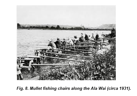
Gone too are the mullet fishing chairs that dotted the south and eastern shores of O‘ahu (figures 7 and 8). Coastal fishermen at Ala Moana, Ala Wai and Wailupe awaited the annual run as it also attracted predator fish like the ulua (giant trevally). The loss of the annual ‘anae holo of the native striped mullet may be the most notable ecological and cultural change experienced at Maunalua.

Gone too are the reef walks at night to torch fish at night. The reefs have been smothered and hardened by silt, urban runoff and invasive species and are disturbed by ever increasing ocean recreation activities. Following the construction of Hawaii Kai Marina, these activities expanded exponentially in Maunalua Bay and led to the establishment of an Ocean Recreation Management Area (ORMA). This in turn resulted in ramp permits, Ocean Recreational Management Area Use Permits for thrill craft and parasailing, and Commercial Use Permits (CUP) by the state Department of Land and Natural Resources. Commercial uses include surfing, canoe and SUP (stand-up) board instruction, canoe and kayak tours, fishing tours, scuba diving, parasailing, whale watching and day tours. The reef adjacent to the main channel is agitated almost daily by these activities, causing the loss of habitat for indigenous fishes.
Gone too are the endangered ae`o (Hawaiian Stilts) from Kuapa Pond due to habitat lost from alterations to vital estuary systems.

Gone too are the reef walks at night to torch fish at night. The reefs have been smothered and hardened by silt, urban runoff and invasive species and are disturbed by ever increasing ocean recreation activities. Following the construction of Hawaii Kai Marina, these activities expanded exponentially in Maunalua Bay and led to the establishment of an Ocean Recreation Management Area (ORMA). This in turn resulted in ramp permits, Ocean Recreational Management Area Use Permits for thrill craft and parasailing, and Commercial Use Permits (CUP) by the state Department of Land and Natural Resources. Commercial uses include surfing, canoe and SUP (stand-up) board instruction, canoe and kayak tours, fishing tours, scuba diving, parasailing, whale watching and day tours. The reef adjacent to the main channel is agitated almost daily by these activities, causing the loss of habitat for indigenous fishes.
Our Failed Kuleana and Restoration Efforts

The failure of the state and its residents to meet its kuleana at Maunalua has resulted in a conscious anthropogenic environmental degradation that has effectively destroyed this historical, vibrant, and productive native ecosystem.
There is much talk today about the relationship between mauka and makai. Meanwhile, construction continues on residential subdivisions, shopping centers, golf courses and supporting infrastructure. And so too continues the introduction of alien species, severing of aquifers, hardening of streams, diversion of surface runoff into sewers emptying directly into the ocean and destruction of fishponds, wetlands and muliwai ecosystems. Through the urbanization of Maunalua, most of the accessible permeable valleys, hillsides and mountains—which have historically fed the aquifers through the percolation of rainwater—have been built over (figure 9).
For millennia, Native Hawaiians ensured Maunalua’s sustainability, defined as the “avoidance of the depletion of natural resources in order to maintain an ecological balance” for future generations. It is time to embrace their knowledge and proven practices and to stop the willful degradation of this place many call home.
Several groups have been active in attempts to restore Maunalua and openly invite others to join them.
The non-profit group Mālama Maunalua, founded in October 2005, works to restore the health of the bay “through habitat restoration, science and planning, and education and outreach;” Significant progress is being made to the bay’s health and will hopefully continue trending positively. In 2021, Mālama Maunalua and its 1,443 volunteers have removed 41,715 pounds of invasive algae, fragmented 141 coral colonies for planting, deployed 6,000 urchins and educated 2,462 students (Mālama Maunalua n.d.).
The Trust for Public Land and the Maunalua Fishpond Heritage Center have embarked on preserving and restoring some of the remaining fishponds including Kānewa‘i Spring, which kūpuna say is “where the mountain gives birth to the ocean.” In 2021, the Maunalua Fishpond Heritage Center worked with State Representative Mark Hashem to secure $1 million for the reconnection and long awaited repair of the water flow at Kalauha‘iha‘i (Maunalua Fishpond Heritage Center 2022).
In 2022, Livable Hawaii Kai Hui brokered a deal to purchase a large swath of Paiko Ridge in order to protect it from development (Wu 2022).
The Pacific Islands Fisheries Group is also engaged in the efforts to restore Maunalua. Its vision is a follows:
“As islands, protecting our natural resources is essential as we continue to ‘promote’ Hawai‘i’s natural beauty and unique resources that drive our visitor industry, but we are failing to ensure the importance of keeping Hawai‘i, Hawai‘i. We are overtaxing, destroying and depleting our natural resources without care or thought about each island’s unique natural resources, beauty, history, character and, most critically, neglecting their carrying capacity resulting in the exodus of kama‘aina (native born) and influx of malihini (newcomers).
“Topmost on this list of essential natural resources is protecting the sources and flow of our fresh water. The wai is the life blood of our survival and demands our immediate attention and action keyed toward ensuring our state’s food security and resource sustainability! The following chant captures the critical role of freshwater in island ecosystems.”
Rainfall and Maunalua
(Source: He mele No Kualii)
E Ku-e-ma Kekaha ka uae Ku,
I ai nakaia o Maunalua.
Say, Ku, the rain comes by way of Kekaha, Ku,
Bringing food for the fish of Maunalua
PIFG encourages the government, community members and visitors to embrace the following:
1. Respect our island communities - Determine and adhere to the carrying capacities of each Hawaiian island with regard to land and water resources to ensure our sustainable future.
2. Leadership - Adhere to the Hawaii State Planning Act as codified under HRS Chapter 226:
a. Identify critical environmental areas in Hawai‘i to include but not limited to the following: watershed and recharge areas; wildlife habitats (on land and in the ocean); areas with endangered species of plants and wildlife; natural streams and water bodies; scenic and recreational shoreline resources; open space and natural areas; historic and cultural sites; areas particularly sensitive to reduction in water and air quality; and scenic resources;
b. Utilize Hawai‘i’s limited land resources wisely while protecting the environment and ensuring the availability of the shoreline, conservation lands and other limited resources for future generations;
c. Direct future urban development away from critical environmental areas OR impose mitigating measures minimizing the negative impacts on the environment; and
d. Identify areas where priority should be given to preserving rural character and lifestyle.
3. Community commitment and actions – Hold elected officials’ administrators and community boards accountable to fundamental sustainability goals and protecting them.
a. Protect the watershed area at Maunalua and ensure against future degradation of them (Parham et al. 2008).
i. Kamilo Iki – Hawaii Kai
ii. Kamilo Nui – Kuli‘ou‘ou
iii. Pia – Niu
iv. Wailupe – Wailupe and ‘Āina Haina
b. Increase community awareness to protect against pollution in streams and surface runoff.
c. Ensure limiting the increased proliferation of ocean activities that further impact Maunalua’s coastal ecosystems and waters.
d. Support local non-profits that are protectors of Maunalua.
4. Individual commitment and actions
a. Respect and live the Hawai‘i’s state motto, Ua Mau ke Ea o ka ʻĀina i ka Pono ("the life of the land is perpetuated in righteousness”). This Hawaiian phrase, spoken by Kamehameha III, was adopted by the state in 1959.
b. Practice actions to protect Maunalua
i. Read E Mālama I Nā ‘Āina Kumu Wai O Maunalua, A Watershed Handbook for the Residents of Maunalua (Wagner 2011).
ii. Follow these simple actions for a healthy bay contained in the booklet:
· Water your yard efficiently. Avoid runoff. (Chapter 2)
· Keep cuttings and debris out of storm drains.
· Use the minimum amount of fertilizers and pesticides. A little goes a long way! (Chapter 4)
· Be careful with household chemicals, which can be washed into the bay. (Chapter 6)
· Clean up pet waste. It’s best to throw it in the garbage or flush it down the toilet. Pet and animal waste contains bacteria, viruses, parasites, and nutrients that pollute water and are harmful to humans, aquatic life, and the ocean.
· Prevent mud from running off your yard and report mud running off from construction sites. (Chapter 4)
· Take care of your car. If you see fluid under your car, see a mechanic. Make sure your brakes are not worn. Corrosion of vehicle parts is a source of heavy metals that end up on roads and get washed out to the bay.
· Become an ambassador for the bay. Keep your eyes open and report problems. Talk to your neighbors. (Chapter 7)
5. Fishermen – Take and practice the “PIFG Fishermen’s Pledge for the Future” (www.fishtoday.org/wp-content/uploads/2011/08/the_pifg_pledge_july20.pdf)
a. Learn and follow fishing laws and regulations that apply to my fishing location and practices.
b. Take only what is needed and practicing “catch & release” of fish that are unwanted or prohibited from being retained.
c. Practice safe fishing principles and safety at sea by following the relevant laws and using common sense to prevent injury to one’s self, others and property.
d. Engage in rule making processes that determine how our shared resources will be managed.
e. Be respectful of other resource users:
i. Do not overcrowd areas or interfere with other fishermen or resource users;
ii. Observe private property by always ask and receive permission before entering private lands; and
iii. Respect all fishing practices, traditions and cultures and take time to engage others in positive dialog.
f. Be knowledgeable about and respectful of all natural resources:
i. Observe, monitor and investigate the condition of our resources;
ii. Learn the life cycles of fish, so you know when it is best to sustainably fish for them;
iii. Be mindful of catching juvenile fish that have yet been able to reproduce; and
iv. Protect and monitor fish habitat and report changes or degradation to appropriate authorities.
g. Properly dispose of ‘ōpala (trash):
i. Always contain and remove trash (plastics, old bait, fishing line, etc.), and leave fishing areas cleaner than upon arrival;
ii. Help to remove excess trash (go beyond your part); and
iii. Report the location of large marine debris to proper authorities.
h. Set a good example for others to follow—“walk the talk”—as good fishing and conservation practices and fellowship are infectious.
State Motto of Hawaii as originally stated by King Kamehameha III.
Ua Mau ke Ea o ka ʻĀina i ka Pono
“The life of the land is perpetuated in righteousness”
Works Cited
Atkinson A. 2007 August 21. Natural and cultural history of Maunalua Bay and its watershed. [Accessed 2023 June 20] https://www.malamamaunalua.org/wp-content/uploads/Atkinson-2007.pdf
Cassady K. 2022 Jan 23. Moving to Kahala? Ultimate guide to lifestyle, restaurants and real estate in Kahala, Hawaii. Dwell Hawaii. [Accessed 2022 June 20] https://www.dwellhawaii.com/blog/moving-kahala-ultimate-guide-lifestyle-restaurants-and-real-estate-kahala-hawaii/
Climate Resilience Collaborative. 2021 July. Wailupe to Niu, O’ahu. [Accessed 2023 June 20] https://www.soest.hawaii.edu/crc/index.php/resources-2/historical-mosaics/wailupe-niu/
Franklin K. 2007 Nov 3. Wailupe Fishpond–Ahupua‘a ‘o Wailupe. Geographical sites of Hawaii. [Accessed 2022 Jun 20] http://hawaiisites.blogspot.com/2007/11/wailupe-fishpond-ahupuaa-o-wailupe.html
Hawaii 24/7. 2019 Mar 1. Know your mullets. [Accessed 2023 June 20] https://hawaii247.com/2019/03/01/know-your-mullets/
Honda P. 2020 Aug 20. Wailupe Valley: Wailupe, Kulu'i streams. Pickled Mango
Hawaii. [Accessed 2022 June 20] http://pickledmangohawaii.blogspot.com/2020/08/wailupe-valley-wailupe-kului-streams.html
King, 1935:216
Ko‘olaupoko Hawaiian Civic Club. n.d. Ahupua‘a Waimanalo. https://www.koolaupoko-hcc.org/wp-content/uploads/2013/01/Waimanalo.pdf
Maunalua Fishpond Heritage Center. 2018 Aug 11. When the limu kala disappears. [Accessed 2023 June 20] https://www.facebook.com/MaunaluaFishpond/posts/2077474208989296/
Mālama Maunalua. 2006 Dec. Maunalua Bay Conservation Action Plan.
[Accessed 2022 June 20] https://www.conservationgateway.org/Documents/Maunalua-Bay-CAP.pdf
———. 2022. Malama Maunalua’s post. LinkedIn. [Accessed 2023 June 20] https://www.linkedin.com/posts/malama-maunalua_an-exciting-update-from-our-friends-at-maunalua-activity-6974124594131587072-DxS2
———. n.d. 2021 Annual Report. [Accessed 2023 June 20] https://www.malamamaunalua.org/wp-content/uploads/FINAL-2-2021-Malama-Maunalua-Annual-Report-10.pdf
Maunalua.net. n.d.(a) Exploring the history of Maunalua. [Accessed 2022 June
20] http://www.maunalua.net/
———. n.d.(b) Lukela. [Accessed 2023 June 20] https://www.maunalua.net/lukela.html
Parham JE, Higashi GR, Lapp EK, Kuamo‘o DGK, Nishimoto RT, Hau S, Fitzsimons JM, Polhemus DA, Devick WS. 2008. Atlas of Hawaiian watersheds and their aquatic resources. Hawai‘i Division of Aquatic Resources and Bishop Museum. [Accessed 2023 June 20] https://www.hawaiiwatershedatlas.com/index.html
Place names of Hanauma. n.d. Maunalua. [Accessed 2022 June 20]
http://placenamesofhanauma.weebly.com/maunalua.html
Takemoto AH, Joerger PK, Mitchell M-EF, Bareng CE. 1975 May.
Historical/cultural essay report on the Kuapa Pond area. [Accessed 2022 June 24] http://www.malamamaunalua.org/wp-content/uploads/Kuapa-Pond-Report.pdf
Vukelich B. 2019 Apr 8. Best Oahu neighborhoods Pt 1: Aina Haina. Hawaii Life.
[Accessed 2022 June 20] https://www.hawaiilife.com/blog/best-oahu-neighborhoods-pt-1-aina-haina/
Wagner J. 2011. E mālama i nā ‘āina kumu wai o Maunalua, A watershed handbook for residents of Maunalua. Univ of Hawaii Sea Grant Coll Prog. [Accessed 2023 June 20] https://nsgl.gso.uri.edu/hawau/hawauh11004.pdf
Wu N. 2022 July 29. Nonprofit purchase deal protects Paiko Ridge in perpetuity. Honolulu Star-Advertiser. [Accessed 2023 June 20] https://www.staradvertiser.com/2022/07/29/hawaii-news/nonprofit-purchase-deal-protects-paiko-ridge-in-perpetuity/
Young PT. 2012 Sept 4. Kuapā Pond (Keahupuaomaunalua Pond). [Accessed 2022
June 20] http://totakeresponsibility.blogspot.com/2012/09/kuapa-pond-keahupuaomaunalua-pond.html
———. 2013 Oct 13. ʻĀina Haina (ʻIli of Wailupe). Images of Old Hawai‘i. [Accessed 2022 June 20] https://imagesofoldhawaii.com/%CA%BBaina-haina-%CA%BBili-of-wailupe/
———. 2016 Apr 21. Wai‘alae Shopping Center. Images of Old Hawai‘i. [Accessed 2022 June 20] https://imagesofoldhawaii.com/waialae-shopping-center/
———. 2019 July 28. Fishponds. Images of old Hawai‘i. [Accessed 2022 June 20] https://imagesofoldhawaii.com/fishponds/
Additional References
Coleman H. 2014 May. Ke kula wela la o Pahua Cultural and historical significance of Pahua Heiau, Maunalua, O‘ahu. Office of Hawaiian Affairs. https://www.malamamaunalua.org/wp-content/uploads/Coleman-2014.pdf
Encyclopedia Britannica. 2006 Nov 2. Koko Head. https://www.britannica.com/place/Koko-Head
Fujikane C. 2011 June 15. A Story of Displacement. Kahea.
http://kahea.org/blog/a-story-of-dispacement
Groves J. 2021 June 15. Koko head hike: 1,048 railway stairs to the crater. Journey Era.
https://www.journeyera.com/koko-head-hike-stairs/
Handy ESC, Handy EG, Puku‘i MK. 1972. Native planters in old Hawai‘i. Honolulu: Bishop Museum Bull 233.
Hawai‘i Division of Aquatic Resources. n.d. Stakeholders seek to set the course to sustainable fishing in Maunalua Bay. https://dlnr.hawaii.gov/dar/announcements/stakeholders-seek-to-set-the-course-to-sustainable-fishing-in-maunalua-bay-2/
HiEstates. n.d. A Brief History of Kahala, the Best Neighborhood on Oahu. https://www.hiestates.com/kahala/a-brief-history/
Historic Hawaii Foundation. n.d. Kalauha‘eha‘e Fishpond.
https://historichawaii.org/2014/02/21/kalauhaehae-fishpond/
Kamakau SM. 1964. Ka po‘e kahiko. The people of old. Honolulu: Bishop Museum Press.
———. 1991. Tales and traditions of people of old: Na mo`olelo a ka po‘e kahiko
Honolulu: Bishop Museum Press.
Kokonut Koalition. n.d. Brief history of the Koko Crater tramway. http://www.kokonutkoalition.org/index.php/about-koko-crater/history
Legend of the Anae Holo. 1908 Dec 11. Kuokoa Home Rula, Vol VI, Number 50.
Lind HY. 2009 April 19. Personal correspondence. https://www.ilind.net/oldkine_images/helen_lind_2009.pdf.
Lind I. 2013 March 30. Recollections of Old Kahala.
https://www.ilind.net/2013/03/30/recollections-of-old-kahala/
Malama Maunalua. n.d. https://www.malamamaunalua.org/
Maly K, Maly O. 2003. Ka hana lawai‘a a me na koʻa o na kai ʻewalu, History of fishing practices and marine fisheries of the Hawaiian Islands. Kumu Pono Associates LLC.
Maunalua Fishpond Heritage Center Kanewai Spring. https://maunaluafishpond.org/
Puku‘i MK, Elbert SH, Mookini ET. 1976. Place Names of Hawaii. Honolulu: University of Hawai‘i Press.
Segall B. 2014 May 24. Geographical History of Kahala. HiEstates blog. https://hiestatesblog.wordpress.com/2014/05/24/geographical-history-of-kahala/
Stearns HT. 1939. Geologic Map and Guide of the Island of Oahu, Hawaii: with a
Chapter on Mineral Resources. U.S. Geological Survey.
Stump JB. Our Hawai‘i Kai: A history of Hawai‘i Kai and Maunalua, Book 1, Manuscript. Hanauma Bay Education Program Library.
This Hawaii Life. n.d. Visit Hawaii Kai. https://thishawaiilife.com/hawaii-kai/